Garnet Peak is the hike I'd send you on first in the Laguna Mountains. My local's guide to this short climb to a 5,900-foot summit with sweeping desert and mountain views.
Garnet Peak, Mount Laguna: My Local's Guide to One of San Diego's Best Views
If you've never made the drive out to the Laguna Mountains, Garnet Peak is the hike I'd send you on first. It's a short climb to a summit that sits right on the edge of the world — the spot where the alpine Laguna Mountains drop nearly a vertical mile straight down to the Anza-Borrego desert floor. You get pine forest behind you, raw desert in front of you, and a 360-degree view that takes in the Salton Sea, San Jacinto, San Gorgonio, and half of San Diego's backcountry. For the effort involved, there's no better payoff in the county.
It's a moderate out-and-back of roughly 2.4 to 2.5 miles with about 500 feet of elevation gain, and most people knock it out in 1.5 to 2 hours. It sits up around 5,900 feet, about an hour and a half east of the city in the Cleveland National Forest. Here's everything I'd tell a friend before they go.
The Quick Version
If you only read one section, make it this:
- Start early — and this one's about elevation, not just heat. At 5,900 feet the views are best at sunrise (there's a reason it's called Sunrise Highway), and the early start beats both the crowds and the summit wind.
- The summit is rocky and completely exposed. The last push involves some loose gravel and a little light scrambling, and the top gets windy. Bring a layer even in summer.
- There's almost no shade. Old fire damage means the tree cover is thin, so pack more water and sunscreen than you think you need.
- Know your trailhead. Penny Pines has free, ample parking; the Garnet Peak trailhead is closer but tiny (a few cars) and needs an Adventure Pass.
- Plan for no cell service. You're in a national forest — don't count on a signal.
Trail Overview
Garnet Peak is one of those rare hikes where a little effort buys an enormous view. The trail climbs through high-country chaparral and the remains of a Jeffrey pine forest before joining the Pacific Crest Trail, then breaks off and climbs the rocky spine to the summit. That PCT connection is part of the fun — you're walking a stretch of the same trail that runs from Mexico to Canada.
A few quick facts to set expectations:
- Distance: ~2.4–2.5 miles round trip (longer if you start from Penny Pines or Pioneer Mail)
- Elevation gain: ~500 feet
- Summit elevation: ~5,900 feet
- Difficulty: Moderate — short, but rocky near the top
- Time: 1.5–2 hours
- Dogs: Allowed on leash (but think twice in summer heat — see below)
- Open: Year-round, though winter can bring snow and ice
One thing worth clearing up: don't confuse Garnet Peak with Garnet Mountain. They're different spots a few miles apart, and Garnet Mountain doesn't have a maintained trail. Your GPS may try to send you the wrong way, so navigate to the trailhead you actually want.
Where to Park and How to Get There
From San Diego, take I-8 East toward El Centro and exit onto S1 / Sunrise Highway, then head north. You've got three trailhead options, and the right one depends on how long a hike you want.
Penny Pines Trailhead (around mile marker 27.3–27.8) is the one I'd point most people to. There's a wide parking area on both sides of the highway, it's well marked with an interpretive sign, and the parking is free. From here, you follow the PCT north along the escarpment — with views the entire way — until you reach the marked Garnet Peak junction and climb to the summit. It's a slightly longer route, but the scenery makes it the most rewarding.
The Garnet Peak Trailhead (a small pullout off Sunrise Highway near mile marker 27.8) is the shortest, most direct route to the top. The catch: there's room for only a few cars, the approach has fewer views than the PCT route, and you'll need a National Forest Adventure Pass (or an America the Beautiful / Interagency pass) displayed to park.
Pioneer Mail Picnic Area (mile marker 29.3) is the option for a longer day — it adds significant mileage along the PCT before you reach the peak.
Whichever you pick, double-check pass requirements before you go, since the rules differ by lot. Facilities are minimal to nonexistent at all of them, so come prepared.
What to Expect on the Hike
The first stretch is gentle. From the trailhead you head northeast across relatively flat ground, winding through chaparral and the scarred remains of a pine forest burned in past wildfires — you'll still see the old fire damage, which is exactly why there's so little shade up here. After about half a mile, you hit the Pacific Crest Trail.
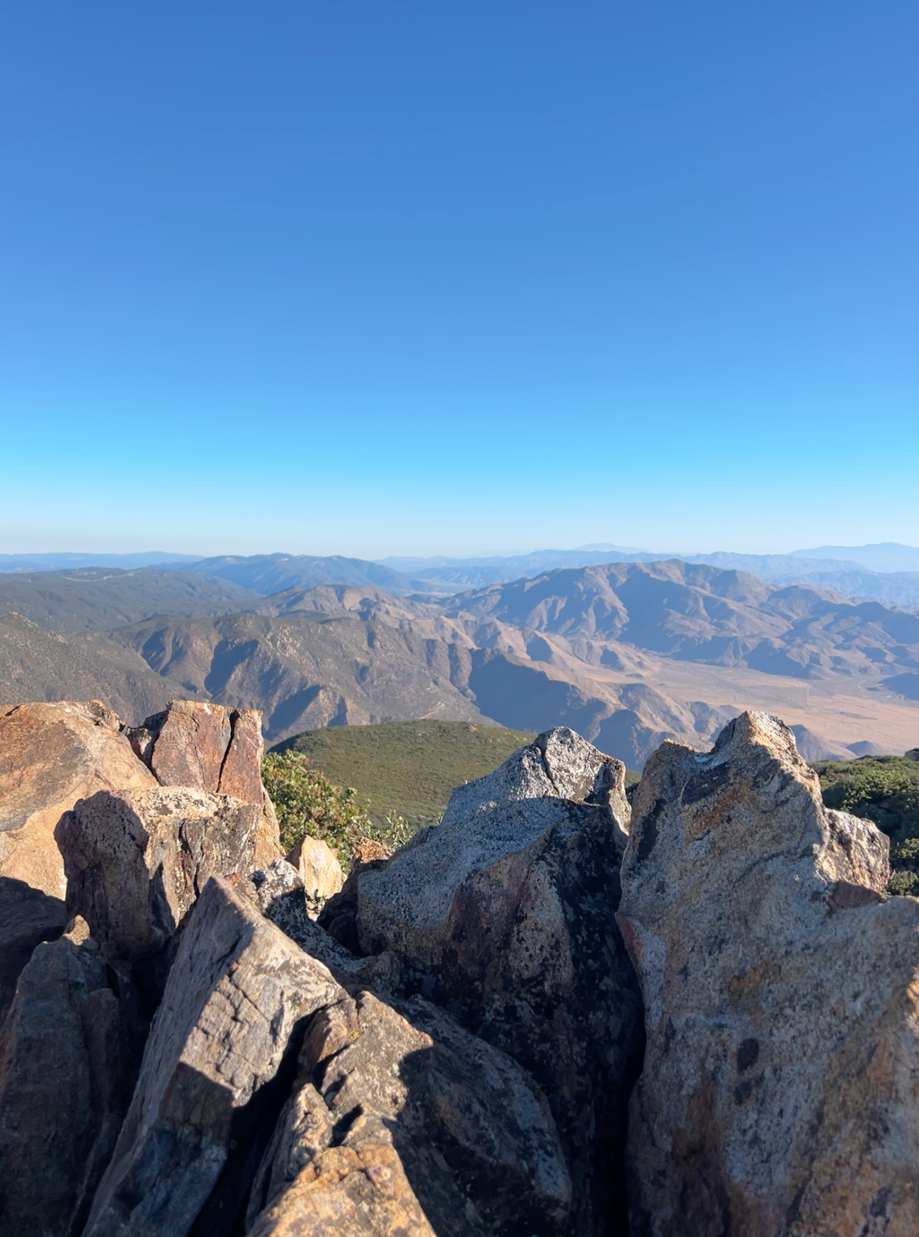
This is where it gets good. As you follow the PCT, the land falls away to your east and the views open up across Storm Canyon toward Monument Peak, then out over the Vallecito Valley and the Borrego Desert. The summit of Garnet Peak comes into view ahead — rocky and a little dramatic-looking. Don't let it intimidate you; it's very doable.
At the marked junction, the Garnet Peak Trail branches off and the real climb begins. The path gets steeper and rockier here, with loose gravel and a few spots near the top where you'll use your hands to scramble over rock. Take your time and watch your footing.
Then you're on top, and it's worth every step. The east face drops away almost vertically toward the desert, and on a clear day the view stretches to the Salton Sea to the east, Cuyamaca and Stonewall Peaks and Palomar Mountain to the west and north, and the distant outlines of San Jacinto and San Gorgonio beyond. There are plenty of rock outcrops to sit on, catch your breath, and take it all in before you head back down the way you came.
When to Go
Sunrise is the move. The summit faces east over the desert, so dawn lights the whole sky up — it's genuinely one of the best sunrise spots in the county, and starting early also means fewer people and calmer air.
By season, spring is my favorite for the wildflowers along the trail, and fall brings crisp air and clear, long-distance views. Summer is fine if you go early, but remember there's no shade up top and it can get warm. Winter is beautiful with a dusting of snow, but the Laguna Mountains can ice over and Sunrise Highway sometimes requires chains — check conditions before you drive out.
What to Bring
- Plenty of water — there's no shade and no water on the trail
- Sunscreen, a hat, and sunglasses
- A windproof layer — the summit is exposed and often windy, even in summer
- Sturdy shoes with good traction for the loose, rocky sections near the top
- Snacks to enjoy at the summit
- Your parking pass, if you're using the Garnet Peak or Pioneer Mail trailheads
- A downloaded map — cell service is unreliable out here
Is It Worth It?
Without question. Garnet Peak gives you one of the most dramatic views in all of San Diego County for a fraction of the effort most summit hikes demand. Start at Penny Pines for the free parking and the scenic PCT approach, go at sunrise if you can swing it, and bring a layer for that summit wind. It's a bit of a drive from the coast, but the moment you're standing on that rocky edge with the desert spread out a mile below, you'll understand why locals keep coming back.
For more San Diego trails, check out our Cowles Mountain hiking guide or browse our Get Outside section.